fbpx

Selected Area: Murrumbidgee

The Murrumbidgee is a lowland river system with large meandering channels, wetlands, lakes, swamps and creek lines. Our work here focuses on understanding how native fish, waterbirds, reptiles and amphibians, as well as wetland vegetation communities, benefit from these targeted environmental watering actions.

Image: Lowbidgee wetland. NSW. Photo credit: Charles Sturt University

Latest updates

Please visit the Commonwealth Environmental Water Office (CEWO) website for:

We are honoured to work on the ancestral lands of the Wiradjuri, Nari-Nari and Mutti Mutti People. We recognise their unique ability to care for Country and their deep spiritual connection to it. We honour Elders past and present whose knowledge and wisdom has ensured the continuation of culture and traditional practices. We are committed to genuinely partner, and meaningfully engage, with Traditional Owners and Aboriginal communities to support the protection of Country, the maintenance of spiritual and cultural practices and their broader aspirations in the 21st century and beyond.

Artwork credit: Wiradjuri Artist Rebecca Salcole

About Murrumbidgee

Covering 81,527 km2, the Murrumbidgee catchment is one of the largest in the Murray-Darling Basin. Nationally important wetlands, including the mid-Murrumbidgee and Lowbidgee floodplain, cover more than 2.5% of the catchment area. With the expansion of agriculture across the region, river flows have undergone significant long-term changes due to the construction of large headwater dams and in-channel weirs. These structures have enabled regulation of river flows and water diversion to accommodate agricultural and consumptive needs. Much of the Lowbidgee floodplain and associated wetlands no longer experience a natural flooding regime and, as a result, the system has become degraded, with many animal and plant species in decline, or threatened with local extinction.

With the aim of improving flows and the health of wetland vegetation communities in the Murrumbidgee Selected Area, priority wetlands with high conservation value receive Commonwealth and other sources of environmental water. Our monitoring program focuses on understanding how native fish, waterbirds, reptiles and amphibians, as well as wetland vegetation communities, benefit from these targeted environmental watering actions. Insights gained from our research are widely shared with the local community as well as the Murray-Darling Basin Authority, Commonwealth Environmental Water Office and environmental water managers to help guide management actions and watering objectives.

Figure 1: Location of Murrumbidgee Selected Area. Source: Skye Wassens

Why this area is important

The Murrumbidgee Selected Area covers over 600 km² of lowland river system, with over 1000 connected oxbow lagoons in the mid-reaches, and 150,000 ha plus of wetlands, lakes, swamps and creek lines in the lower reaches before it merges with the Murray River. The region supports a braided network of creeks and lignum swamps, and some of the most extensive, intact stands of River red gum forest and aquatic grassy meadow communities in Australia. It also supports a number of wetlands of national significance, a rich diversity of colonial nesting waterbirds, specialised native floodplain fish, and significant populations of the threatened Southern bell frog and Australasian bittern.

The Murrumbidgee is also a working river, supporting broad areas of irrigated agriculture that underpin rural economies. As a result of the high rates of extraction and regulation, water managers strive to balance the needs of communities, agriculture and the environment. The delivery of environmental water in the Murrumbidgee is carefully managed, with a core focus being the precise delivery of water to the high value wetlands and riverine assets that make up critical habitat to maintain regional biodiversity. Our work here provides knowledge to underpin water management and delivery decisions so that the environmental outcomes are maximised.

Our approach

Our team of researchers include scientists and technicians from Charles Sturt University (CSU), Department of Planning, Infrastructure and Environment (Fisheries), DPE Environment and Heritage Group, and the University of New South Wales. We study riverine and wetland habitats, and collect a broad range of data on:

  • native and exotic fish communities and their spawning events
  • colonial and migratory waterbird numbers and their breeding events
  • floodplain frog diversity and call phenology (relates to frog life cycle events)
  • water quality and stream metabolism

We also monitor changes in wetland vegetation communities, as well as modelling river flows and wetland hydrology, investigating inundation area (extent of flow/flooding), frequency and water depth. From the monitoring data we gather we then analyse and evaluate interactions and relationships between biodiversity responses and environmental watering actions. This knowledge can then be used to inform the adaptive management of environmental water delivery. Our activities include:

Field surveys – We conduct extensive on-ground field surveys and monitor the response of vegetation communities and wildlife populations to targeted environmental watering actions across different wetland zones and river reaches.

Data analysis and modelling – We run complex analyses to evaluate the relationship between wildlife responses and watering actions of key wetlands.

Reporting – We produce high quality publications, reports and newsletters for the Commonwealth Environmental Water Office and other environmental water managers in NSW to help inform future water planning actions.

Community engagement – We work with a broad range of stakeholders including private and public landholders, and share our findings via community-based engagement and awareness activities, and science communication products.

Research team members conducting waterbird surveys. Photo credit: Charles Sturt University.
Research team processing wetland fish in the Lowbidgee wetland zone, NSW. Photo credit: Charles Sturt University.

Current activities

Our core research activities centre on a long-term, broad-scale biodiversity monitoring program that focuses on riverine and wetland fish communities, larval fish recruitment, waterbird diversity and breeding events, frog and turtle diversity, vegetation diversity, water quality and stream metabolism. These carefully chosen key indicators have been systematically collected over the past five years to provide the Commonwealth Environmental Water Office and other water managers with vital information to help inform planning of environmental watering actions.

Our team is also involved in several other collaborative research projects.

Benchmarking vegetation across the Murrumbidgee Selected Area

The watering regime, which includes frequency, duration and water depth, plays a critical role in structuring aquatic vegetation communities. Prolonged drought and altered flow regimes can reduce the diversity and cover of aquatic species, leading to declines in seed banks and reduced recovery times. Water for the environment has an important role in maintaining both vegetation species diversity within wetlands, and overall vegetation community diversity across the Murrumbidgee catchment. By reinstating more natural flow regimes, environmental water can play an important role in the recovery of aquatic vegetation communities and culturally important wetland plants.

This project aims to collect baseline data on the vegetation condition of priority wetland sites that receive Commonwealth environmental water or have the potential to receive Commonwealth environmental water in the future. The baseline data that is being collected will serve as a reference point against which future watering actions can be evaluated, support water planning including assessing suitability of wetland sites for Commonwealth environmental water, assist in refining watering objectives and recovery targets as well as identifying habitat suitability for other water dependant fauna.

Benchmarking vegetation Charles Sturt University team member Gaye Bourke downloading data from a temperature logger. Photo credit: Damian Michael

Developing optimisation models for improved water management

An important part of improving conservation outcomes in freshwater ecosystems requires us to develop a common understanding of how the system responds to environmental conditions and water management actions. Developing statistical process models for components of the ecosystem by linking environmental conditions (e.g. water availability and temperature) with the response of plants and animals, is the first step. Accurate predictions of how selected indicators (e.g. fish and frog diversity) respond to environmental conditions and management actions can be developed using data-driven statistical models. Following on from this step, biological response models can be integrated to form a cohesive process model for the entire ecosystem, forming the foundation for optimising decision making for floodplain and wetland restoration, and planning for adaptive water management.

This project involves developing ecological response models for the Murrumbidgee floodplain that summarises the current understanding of system requirements, inter-annual dynamics, and anticipated short and long-term responses of the system to management actions such as environmental flows or natural flood events. The statistical models will capture the cause-and-effect processes that drive ecosystems responses, by identifying key drivers (e.g. water depth, temperature) for predicting ecological responses, and explicitly identify uncertainties in current knowledge and capacity for accurate predictions thereby informing future monitoring priorities.

Data used to inform statistical models are collected from managed wetlands in the Selected Area like this one in the Lowbidgee, NSW. Photo credit: Charles Sturt University.

Understanding native fish dispersal, recruitment and habitat refuge

The Golden perch is a freshwater fish species with flexible spawning strategies adapted for naturally variable river flows. Golden perch populations have, unfortunately, undergone a reduction in range and abundance in the Murrumbidgee River, and elsewhere across the Murray-Darling Basin due to altered flow regimes, cold-water pollution and barriers to fish movement. This species typically spawns during spring flooding events that inundate floodplain environments and, although reports of in-channel spawning across parts of the species geographical range exist, understanding natal (home) origins and specific environmental factors that influence spawning in this species has yet to be resolved at a large scale.

This project builds on an earlier study which aimed to understand the importance of environmental flow-driven floodplain connections in providing food resources for native fish spawning and recruitment. The previous study found evidence to support the delivery of large over-bank environmental flows across the floodplain to maximise the production of food resources supporting Golden perch and Bony bream spawning and recruitment. In the new study, we will focus on identifying refuges and high quality habitat to enable fish movement and recruitment during environmental water delivery. We will also evaluate the effectiveness of restoring wetland fish communities using different delivery mechanisms like pumping infrastructure, regulators or overbank flows to inundate priority wetlands.

Research team processing wetland fish in the Lowbidgee wetland zone, NSW. Photo credit: Charles Sturt University.
Golden perch. Photo credit: Charles Stuart University
Golden perch larvae. Photo credit: DPE Environment and Heritage Group

What we’ve learned

Inundation regime

Inundating is the most influential driver of floodplain wetland ecosystems, as it influences primary production, nutrient and carbon cycling, animal movement patterns and reproductive behaviour. Aspects of the flood pulse with ecological significance include the inundation magnitude (extent), duration, timing, inter-flood dry interval and frequency of pulses. These components of the flood regime are important for promoting River red gum regeneration and triggering waterbird-breeding events.

During the 2016-17, numbers of waterbird species across the region peaked in response to widespread natural flooding with top up deliveries of Commonwealth environmental water to key wetlands that supported waterbird breeding colonies. Our long-term monitoring indicates that inundating large areas of continuous floodplain habitat through spring and summer months increases waterbird diversity and breeding activity.

Image caption: Two Bridges Swamp in the Lowbidgee in one of the 12 wetlands that receive environmental water. Photo credit: Charles Sturt University.
Two Bridges Swamp. Photo credit: CSU
What is the difference between flood and inundation?

While inundation is defined as flooding, there are circumstances where flooding would be appropriate, but inundation would not. Inundation implies extensive water presence. Flooding may sometimes be used to convey unwanted water, but in less than overwhelming amounts.

Lateral connectivity

One effective management strategy to improve riverine and wetland health is to reconnect the river with adjacent wetlands by raising water levels and allowing water to spill over the banks to fill nearby wetlands. Broad-scale wetland reconnections and periods of low flow assist in moving carbon and nutrients from the floodplain to the river, and are necessary to promote resources for river food webs and spawning in native floodplain fish species.

The mid-Murrumbidgee reconnection event in 2017-18 connected a number of oxbow lagoons between Wagga Wagga and Darlington Point. Findings from our monitoring program during this event indicate that higher rates of metabolism and secondary productivity are observed during periods of either very low flow (e.g. during summer months) or very high flows, which inundate substantial area of floodplain and wetland habitat (as was the case in 2016-17).

Reconnection flows might also support dispersal and recolonisation of wetlands by native plant species, as noted by several previously unrecorded aquatic plant species detected at wetlands in the mid-Murrumbidgee following the reconnection. These findings provide some evidence for the benefits of large-scale floodplain inundation and reconnection with the river.

Image caption: Yanga Lake in Yanga National Park is often the recipient of water for the environment to support native fish populations. Photo credit: Charles Sturt University.

Timing of watering actions

The timing of water delivery actions can have a strong influence on the breeding success of species such as floodplain frogs and riverine fish. Water delivered too late in the season may not provide suitable conditions, or provide enough time for some species to breed successfully. The larvae stage is the most critical and vulnerable part of a fish’s life history, with larval fish survival highly dependent on hydrology.

Hydrology was found to influence habitat availability, water temperature, larval dispersal and micro-invertebrate abundance for the crucial first feed following spawning. Commonwealth environmental water deliveries that target native fish responses, have the capacity to positively influence reproductive opportunities and enhance larval survival, thereby increasing recruitment to the wider population. Findings from our monitoring program show that environmental water deliveries in the Murrumbidgee provide suitable hydrological conditions for triggering spawning in species such as Silver perch and Golden perch. We also found that spawning is largely related to water temperate rather than in-channel freshes (increased flows resulting in rises in river water levels).

Image caption: A semi-permeant wetland in Gayini Nimmie-Caira that supports healthy populations of native fish and Southern bell frogs. Photo credit: Charles Sturt University.

Mode of delivery

Given the modest volumes of water for the environment available relative to the area of floodplain and wetland habitats, as well as the need to support multiple water users, there is limited capacity to restore the natural inundation regime using managed river to wetland reconnections alone. The current water management approach for wetlands in parts of the Murrumbidgee region focuses on pumping water for the environment to key wetlands, with occasional reconnection events.

We found that in terms of ecological outcomes per megalitre of water used, pumping has a very high ratio of positive outcomes relative to water volume used. We found that these benefits are highly localised to individual wetlands in close proximity to the river, or irrigation channels and pumps, meaning that a small number of wetlands remain in good condition, while others continue to decline.

Despite this shortcoming, our research shows that management interventions that allow a short drying period, followed by immediate pumping, can be effective in removing a significant number of adult common carp from a wetland, while at the same time allowing small native fish to pass through the pumping infrastructure. These actions contributed to a noticeable increase in small native fish and tadpole abundance at a key wetland in 2018-19, compared to previous years when large numbers of exotic carp were present.

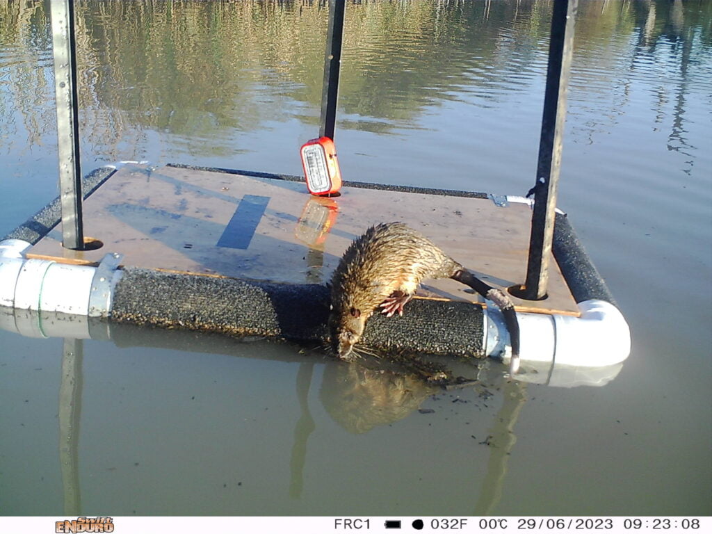
Top image caption: Numbers of exotic species such as this introduced gold fish can be controlled through drying and refilling key wetlands. Photo credit: Damian Michael
Bottom image caption: The native Flat-headed gudgeon is an uncommon inhabitant of freshwater wetlands but has increased in recent years. Photo credit: Damian Michael

Maintaining habitat refuges

Large-bodied native fish such as Bony bream and Freshwater turtles are dependent on the maintenance of permanent wetlands, especially during periods of drought. Freshwater turtles are extremely sensitive to changes in aquatic and terrestrial habitats, with loss and fragmentation of terrestrial and riparian habitats disrupting overwintering and nesting sites, as well as restricting movements among wetlands.

Through our monitoring program, we identified important wetlands that act as habitat refuge for these long-lived species. Our findings suggest that the Eastern long-necked turtle can exploit a wide range of aquatic habitats, while the predominantly riverine species, Macquarie River and Broad-shelled turtles, have more restricted distributions and are closely associated with wetlands that flood, and are close to the river. Maintaining the integrity of these key wetlands with water for the environment to prevent complete drying is critical to ensure the survival of turtle populations.

Image caption: The Broad-shelled turtle is associated with permanent wetlands and riverine habitats. Photo Damian Michael
Peron's Tree Frog, Litoria peroni
Peron's Tree Frog, Litoria peroni. Photo credit: Damian Michael
Red-bellied black snake. Photo credit: Damian Michael

Our team

Professor Skye Wassens

Skye is the Principal Scientist and an internationally recognised ecologist at Charles Sturt University specialising in aquatic ecology and the conservation of wetland-dependent amphibians.

Professor Andrew Hall

Andrew is an earth system scientist at Charles Sturt University with specialist knowledge in climatology and vegetation remote sensing, with his work being reliant on expert application of geographic information science and remote sensing image analysis.

Dr. Anna Turner

Dr Anna Turner

Anna is a research associate and conservation biologist at Charles Sturt University with expertise in amphibian conservation and management, population ecology and wildlife disease.

Dr. Sarah Talbot

Dr. Sarah Talbot

Sarah is a Senior Technical Officer at Charles Sturt University with expertise in project management, aquatic and terrestrial field surveys, data management and curation, and community engagement.

Dr Gilad Bino

Gilad is a Research Fellow at the University of NSW with experience in statistical modelling. His research focuses on understanding the underlying processes shaping biodiversity at multiple spatial and temporal scales.

Dr Jennifer Spencer

Jennifer is a Senior Scientist with the Water and Wetlands Science Division of DPE Environment and Heritage Group. She has extensive expertise in waterbird breeding ecology and ecological monitoring.

Dr Kate Brandis

Kate is a Research Fellow and freshwater ecologist at the University of NSW with specialist expertise in wetland ecology and waterbird breeding ecology.

Dr Yoshi Kobayashi

Yoshi is a Senior Research Scientist and freshwater ecologist with the Department of Planning, Industry and Environment. His research focuses on planktonic microbial communities and their utility in understanding the structure and functioning of aquatic ecosystems.

Dr Rachael Thomas

Rachael is a freshwater ecologist with the Water and Wetlands Science Division of DPE Environment and Heritage Group.

Eva Moore smiling and holding a bearded dragon

Eva Moore

Eva is a Technical Officer at Charles Sturt University with expertise in project organisation, aquatic and terrestrial field surveys, and data management and curation.

Jerom Stocks crouches in a river, holding a Murray cod.

Jerom Stocks

Jerom Stocks is a Fisheries Scientist with expertise in both marine and freshwater ecosystems. Jerom currently works within the Freshwater Ecosystems research group focusing on threatened species recovery, the National Carp Control Plan and coordinates a number of fish community monitoring projects.

Joshua Piesley

Joshua Peisley

Joshua is a First Nations Cadet currently studying for a Bachelor of Environmental Science and Management at Charles Sturt University. Josh has a special interest in bush rehabilitation,  native plants and linking  culture and science.

    Subscribe and get the latest updates in your email inbox

    This page contains information specific to the Murrumbidgee Commonwealth Environmental Water Office (CEWO) Monitoring, Evaluation and Research Project. For further information about water use in the Murrumbidgee catchment, please click here to visit the CEWO website.

    Disclaimer

    The information on this website is presented by the Department of Climate Change, Energy, the Environment and Water (the Department) for the purposes of disseminating information to the public. It does not constitute legal or other professional advice.

    The views and opinions expressed on this website are those of the authors and do not necessarily reflect those of the Australian Government or the Portfolio Ministers for the Department or indicate a commitment to a particular course of action.

    While reasonable efforts have been made to ensure that the contents of this website are factually correct, the Commonwealth of Australia does not accept responsibility for the accuracy or completeness of its contents. The Department disclaims liability, to the extent permitted by law, for any liabilities, losses, damages and costs arising from any reliance on the contents of this website. You should seek legal or other professional advice in relation to your specific circumstances.

    Use of this website is at a user’s own risk and the Department accepts no responsibility for any interference, loss, damage or disruption to your computer system which arises in connection with your use of this website or any linked website.