Autumn Issue | 2023-24
Reading the Goulburn River
Reading the Goulburn River
“Life is good, but it’s better on rivers.”
Explore the Lower Goulburn River as it changes through the seasons.
Welcome to the Autumn edition of Reading the River, the newsletter that keeps you up-to-date with seasonal changes along the Goulburn River.
IN THIS ISSUE:
Helping hands! Rescue operations save crayfish | How the Summer unfolded… | Vegetation response to multiple floods | Snagging a home for native fish | What’s happening in Autumn | Fishing fun at Arcadia Hatchery, and lots more…
COVER STORY
Helping hands! Rescue operation saves crayfish

Crayfish suffering from poor quality water as the result of flooding in the lower Goulburn River were given a helping hand early this year.
Goulburn Broken Catchment Management Authority (GB CMA) staff were out monitoring river conditions downstream of Shepparton in January when they noticed stressed Murray spiny crayfish crawling out of the water or sitting on the edge of the river. The significant rainfall and associated sediment and debris going into the river caused low dissolved oxygen levels, so the crayfish were forced up on to the bank, making them vulnerable to predation.
GB CMA, with the help of Victorian Fisheries Authority Arcadia hatchery staff and local fishing club members rescued 120 crayfish and relocated them upstream to an area where dissolved oxygen levels had improved. Without these helping hands these crays may have died from predation or stress.

Animal in focus: Murray spiny crayfish
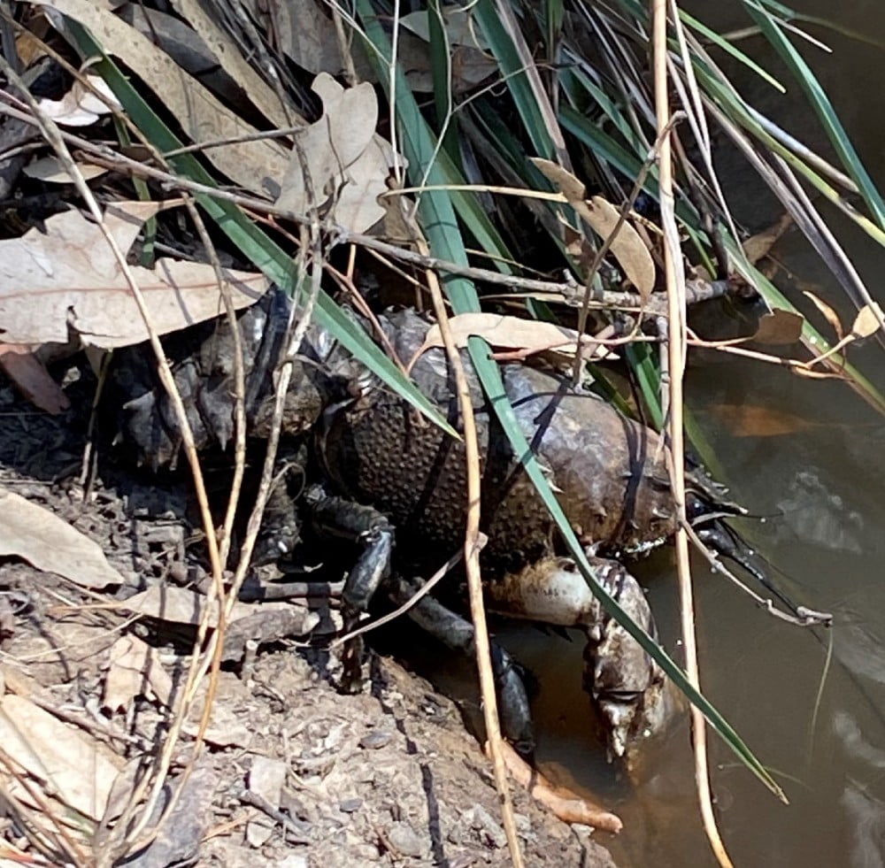
Murray spiny crayfish escaping floodwaters in the lower Goulburn River.
The Murray spiny crayfish (Euatacus armatus) is the second largest freshwater crayfish in the world and is found in the southern waterways of the Murray-Darling Basin, including the lower Goulburn River.
These prehistoric looking creatures can live for more than 30 years and can grow up to 50 cm long; but it takes a long time to reach that length as they’re slow growers with females reaching sexual maturity at 10 years of age. The Murray spiny crayfish is listed as a threatened species in Victoria.
The Murray spiny crayfish prefer cool flowing water but can tolerate warmer water and high salinity, they are very susceptible to low dissolved oxygen levels. They create burrows and will feed on a variety of food depending on what’s available, including dead fish and decaying plant material.
References:
How the Summer unfolded...
The mean maximum temperature in Summer was near average across the Goulburn region, with slightly higher minimum temperatures than the long-term average.
In contrast, rainfall was very much above the long-term average. This was largely due to multiple Summer high rainfall events, with the 6th-7th of January of particular note in the mid Goulburn catchment with rainfall totals between 100-180mm.

This deluge resulted in a natural flood event in the mid and lower Goulburn river. As the high flows moved downstream the dissolved oxygen levels were observed to be dropping to less than 1.5mg/L for several days. Research has shown that, as a general rule, fish and other aquatic biota become significantly stressed when dissolved oxygen levels are less than 2mg/L.
The GB CMA closely monitored the water quality using probes installed at multiple locations, combined with site visits where a handheld portable dissolved oxygen meter was used to monitor the water quality.
In response to the poor water quality and potential impacts on fish, environmental water was used to activate multiple irrigation channel outfalls into the lower Goulburn River. The channel water was high in dissolved oxygen that provided refuge for fish. Minimal reports of fish deaths were reported from this event.
Water for the environment was also used to manage the recession of flows in the lower Goulburn River to minimise the likelihood of mass bank failure from rapid drops in water level.
Live dissolved oxygen levels are available at: Water Quality and Dissolved Oxygen – Goulburn Broken CMA.
Vegetation response to multiple overbank flows
A recent survey of riverbank vegetation showed that we still have extensive cover following the natural flood event in January. These flows provided moisture to enable vegetation to continue growing.
Interestingly, our January surveys found that the diversity of plants has reduced. In December, we recorded sedges and other water tolerant species, but by the end of January the sedges had disappeared to be replaced by plants that can thrive with prolonged inundation. These findings will be used to inform future watering events.

Snagging a home for native fish
Life is looking good for native fish in the Goulburn River near Mitchelton.
Timber, donated from several local projects and organisations, has been placed in the river to provide vital refuge habitat for threatened native fish species such as Macquarie perch, Trout cod and Murray cod.
The large native timber, mainly large logs and rootballs, provides critical shelter, food sources and breeding areas needed by these fish.
What is a hydrograph?
A hydrograph is a graph which shows flows in a river over time, at a particular location. They are a useful tool used by agencies around to world to both plan for how flows may look (such as the one below) and can also be used to show how actual flows occurred after an event.
The Goulburn-Broken CMA has developed a live hydrograph so that you can see whether flows in the river are operational flows, including Inter-Valley Transfers, or water for the environment. See what the hydrograph looks like below and for the live version, please visit the live website to explore.
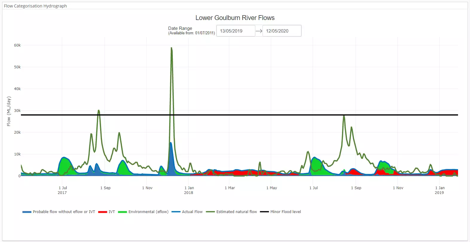
Image: A static image of the Lower Goulburn River hydrograph showing the differences between the estimated natural flow (dark green), actual flow, and sources of water.
What’s happening in the river this Autumn?
Water for the Environment
After yet another natural flood event in January, a planned Autumn fresh will not be delivered in the Goulburn River, as ecological outcomes were met by the minor to moderate January flooding.
Some of the reasons why the Autumn fresh will not go ahead include:
- Flooding in January has provided sufficient moisture for bank vegetation and shortened the available growing season. Extended periods of low flows will allow bank vegetation to recover and grow for the rest of the season;
- With bank vegetation submerged for extended periods and less than four weeks of low flows before the planned timing of the Autumn fresh, it may present a great risk of damaging bank vegetation this year;
- There are limited benefits for native fish from the delivery of the Autumn fresh. Native fish dispersal and movement would have occurred with the January flooding and the fresh will not provide significant feeding or life-cycle benefits;
- The flood event in January, along with environmental water used to slow its recession have met the requirements for scouring of substrate and flushing of sediments. Another fresh so soon after would provide minimal benefits;
- Significant flooding with high flow velocities right through to summer have met the geomorphological processes for this year, so an Autumn fresh is not needed.


The lower Goulburn River will benefit from the continuation of planned variable low flows over Autumn. Flow over this season will be targeted between 600 and 1,000 ML/day, downstream of Goulburn Weir.
Low variable flows provide multiple benefits to the river system including providing plankton production for food and maintaining good water quality. Goulburn Broken Catchment Management Authority staff have observed water clarity has improved in recent months of low variable base flow.
At this stage, there are no plans for any significant Inter Valley Transfers down the lower Goulburn River.
Climate influence on the lower Goulburn River
Issued: 28 March 2024
The Bureau of Meteorology has confirmed El Niño is near its end, with March 2024 as the warmest March on record. The Bureau’s long-range forecast predicts maximum temperatures are likely to be above median in the region between April and June and there is about an equal chance of above and below median rainfall. However, they do predict near median to high stream flows.
What does this mean for the lower Goulburn River?
Between April and June we may see unregulated flows increase in response to rain events. This will increase flow variability and habitat for native fish, waterbugs and platypus. This may also reduce the need to release environmental water.
Autumn statistics:
| April | May | June | Annual | Years | |
| 22.6 | 17.5 | 14.1 | 22.4 | 1996-2024 (28) | |
| 8.7 | 5.6 | 3.8 | 8.8 | 1996-2024 (28) | |
| 37.4 | 33.8 | 41.9 | 451.6 (Annual total) | 1996-2024 (28) | |
| 3.9 | 5.2 | 6.9 | 61.6 (Annual total) | 1996-2024 (28) |
red = highest value
blue = lowest value
Averages are for Shepparton (site number 081125) and sourced from: Climate statistics for Australian locations (bom.gov.au).
What are our monitoring teams up to in Autumn?

Our fish ecologists will be out using a range of techniques to determine the species present, their abundance and breeding success. The survey information will help tell us how species such as Murray cod, trout cod, golden perch and silver perch are responding to flows over time.

Our vegetation ecologists will be out along the banks measuring the cover and range of species which have grown this year, with a keen eye to see how the flooding in January has changed things.

Our monitoring program has a strong focus on channel geomorphology – that is, the structure of the channel. Our geomorphologists will out with their drones to map the river bed, banks and bars, to see how the river has changed over the last 12 months.
The map below shows where we will be doing our monitoring.

What’s been happening in the Catchment?

Fishing fun at Arcadia Hatchery
The first open day for the Arcadia Hatcher was held on Saturday 6 April, providing a chance to learn more about native fish production, First Nations fishing history and interactive activities including learning how to fish.
For more information and to book future visits, see vfa.vic.gov.au/arcadiaopenday

Night time flyers
Nan na na batman! Well maybe not quite Batman with a cape but it will still be a lot of fun. The team at River Connect and the Cussen Park Management Advisory Committee held a bat night at Cussen Park Tatura, to learn about bats in the Goulburn Broken Catchment.
For more information about the night and River Connect, visit Bat Night | RiverConnect
News from the broader Flow-MER Program

Investigating the water requirements of the endangered Australasian bittern
Detecting Australasian bitterns can be a challenge. They are listed as Endangered in Australia with only 1300 estimated left in the wild nationally. They are elusive and well-camouflaged, nest amongst dense wetland vegetation, and male bitterns call at night for part of the year.
As part of the Flow-MER Program, Charles Sturt University (CSU) researchers and NSW Department of Climate Change, Energy, the Environment and Water (DCCEEW) are investigating the relationship between the timing and duration of water for the environment deliveries and bittern calling activity.

Where have all the freshwater mussels gone?
It wasn’t that long ago that freshwater mussels were abundant throughout the Murray-Darling Basin. However, their numbers have drastically declined.
The Edward/Kolety-Wakool monitoring team is trialling new methods to detect freshwater mussels in an effort to understand what has led to their decline. As part of this project, a Knowledge Sharing Day on freshwater mussels was held at the Yarkuwa Indigenous Knowledge Centre, to share knowledge about the cultural and ecological importance of mussels in the region.

Cracking the code: Decoding the Monitoring, Evaluation and Research space – how do they inform effective water management in the Murray–Darling Basin
Water management is certainly full of acronyms and jargon, and monitoring programs are no exception. You might be forgiven for thinking that ‘MD-WERP’, ‘TLM’ and ‘Flow-MER’ are names of 80’s DJs. They are in fact various programs of water delivery, monitoring and research which operate within the Murray-Darling Basin.
This article provides an introduction to these programs, while also sharing case studies on the role of the Flow-MER Program in the water management of the MDB.
Thanks for reading this Autumn edition of the Goulburn Broken ‘Reading the River’ Seasonal Calendar.
Please subscribe here to receive the next edition in your inbox.
The Reading the River publication has been authored by the Lower Goulburn River Selected Area team of the Flow-MER Program. The work of the Lower Goulburn River Selected Area team is to assess how environmental and consumptive flows are affecting the ecosystem of the Lower Goulburn River, to help waterway managers to protect and enhance this vital water source into the future.
To learn more about the Flow-MER Program,
visit Flow-MER – Environmental Water Monitoring, Evaluation and Research
![]()

The Goulburn River is known by several names as it travels first through Taungurung country in the hilly upper and middle reaches. Here, the river is called Waring.
As the river meanders downstream of Murchison and into the northern flatlands, the river winds through Yorta Yorta country. Here the river is called Kaiela, meaning ‘father of waters’. Eventually, the river flows to a confluence with the River Murray near Echuca. This confluence of rivers is known as Koninner.
We acknowledge the Traditional Owners of the country this story has been written about – Taungurung and Yorta Yorta. We pay our respects to elders past, present and emerging.
Artwork credit: Wiradjuri Artist. Rebecca Salcole.