Summer Issue | 2023-24
Reading the Goulburn River
Reading the Goulburn River
“Life is good, but it’s better on rivers.”
Explore the Lower Goulburn River as it changes through the seasons.
IN THIS ISSUE:
Bank vegetation booming! | An update from the Spring rainfall | What flows are likely this Summer | Climate drivers | Golden perch breeding | Platypus spotting | Turtle talks, and lots more…
COVER STORY
River banks are clean, green and growing!
Vegetation on the banks of the Goulburn River is currently thriving. Monitoring in early December found large amounts of healthy, native plants growing on the banks, with plenty of new plant germination visible.
This photo of the Goulburn River at Loch Garry in December shows the groundcover in the foreground is nearly all native plants including native herbs, interspersed with sedges, grasses and rushes.

Update from rainfall in Spring
The unpredictable nature of weather in Spring was demonstrated this year.

There was below average rainfall across the Goulburn Catchment in September. From 3-5 October a cold front and low-pressure system generated widespread rainfall across Victoria. On 4 October, highest October daily totals were recorded throughout the Goulburn catchment including Acheron River at Taggerty (135.4mm), Merton (112.4mm) and Lake Eildon (108mm).
Inflows to Lake Eildon peaked at 120,000 megalitres per day and releases to manage water levels started on 5 October via the spillway (left).
Goulburn Weir releases peaked at 23,000 megalitres per day on 8 October. The lower Goulburn River remained elevated for most of October and the floodplain was once again inundated with minor flooding at Shepparton, with levels remaining below the minor flood level at McCoys Bridge.
November rainfall was variable with storms generating moderate rainfall totals in localised areas.
From an ecological perspective, the elevated flows of relatively short duration at this time of year are largely positive, as it provides further connection to the floodplain for food and habitat. It also increases the moisture in the banks to encourage vegetation growth prior to the warmer and drier summer conditions. Variability in flows during spring is also great for our native fish, providing a range of flowing habitat and food resources.
One potential downside of the high flows is the small chance that it impacts platypus populations. The October water levels were slightly higher than the winter event and this may mean burrows that were dug using winter levels as a cue may have been flooded. It’s unknown if any burrows with young platypus were inundated, and these impacts require further investigation.
Water on the floodplain in October had positive outcomes with numerous small wetlands being refreshed and native vegetation receiving a good drink. Water on the floodplain drowned and killed weeds and allowed native rushes and sedges to flourish (right).
Although the flooding was relatively low and there were no major impacts in the lower Goulburn River, the community was on alert after the 2022 floods.

Goulburn River at McCoys Bridge Hydrograph
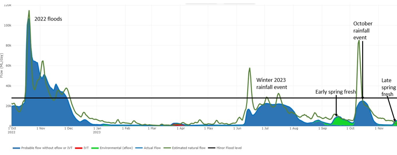
A hydrograph is a graph which shows flows in a river over time, at a particular location. The one above is of the Goulburn River at McCoys Bridge, showing unregulated flows, environmental flows and operational flows including Inter Valley Transfers.
Hydrographs are a useful tool used by agencies around the world to plan for how flows may look and can also be used to show how actual flows occurred after an event. The Goulburn Broken CMA has developed a live hydrograph so you can see whether flows in the river are operational flows, including Inter Valley Transfers, water for the environment or higher natural flows resulting from heavy rainfall.
To see which water sources are contributing to flows in the river, visit the website here.
What’s happening in the river this Summer?
Water for the Environment
After many over-bank flows, combined with in-channel deliveries of water for the environment, the lower Goulburn River is set to benefit from planned variable low flows over summer.
River flow over summer will be targeted between 600 and 1,000 megalitres per day downstream of Goulburn Weir. These flows will:
- Provide slow, shallow habitat required for the recruitment of larval and juvenile fish and habitat for adult small-bodied fish;
- Provide deep-water habitat in pools for large-bodied fish;
- Submerge snags and lower bank vegetation to provide habitat for fish and waterbugs;
- Provide habitat and food for turtles;
- Maintain habitat for aquatic vegetation and water the root zone of lower bank vegetation;
- Vary flow within a specified range to encourage plankton production for food, and maintain water quality;
- Enable vegetation to establish to protect against notching and bank erosion.
Inter Valley Transfers
If dry conditions occur there is the possibility of Inter Valley Transfers down the lower Goulburn River. There are interim rules in place which require Inter Valley Transfers to be done via a series of small pulses, with intervals in-between, rather than prolonged high flows. These requirements aim to prevent notching and bank slumping that can occur from prolonged high flows in summer. Impacts to bank vegetation are also minimised by having shorter inundation events during the warmer months.

Climate influence on the lower Goulburn River
Issued: 14 December 2023
The Bureau of Meteorology has confirmed El Niño continues. Australia’s climate has warmed by 1.48 ± 0.23°C since records began in 1910. The warmer conditions have led to an increase in extreme heat and fire weather. High intensity, short duration rainfall events are more common and overall rainfall totals are likely to be reduced.
What does this mean for the lower Goulburn River?
Reductions in flow and increases in water and air temperature can be stressful for aquatic and floodplain flora and fauna, especially if combined with hypoxic (low oxygen) blackwater or runoff from fire-affected catchments.
The resilience of the lower Goulburn River system to cope with these conditions can be increased through environmental water management and the recent natural wet conditions.
For example, providing deep-water habitat for large-bodied fish through minimum base flows or freshes that increase bank soil moisture and encourage vegetation growth, can provide habitat and food resource.
The impact of hypoxic (low oxygen) water may be reduced by using dilution flows after an event or to provide refuges for aquatic fauna.
For more information on blackwater events including an informative video go to: Water Quality and Dissolved Oxygen – GB CMA – Goulburn Broken CMA
Summer statistics:
| December | January | February | Annual | Years | |
| 29.2 | 32.1 | 30.9 | 22.4 | 1996-2023 (27) | |
| 12.9 | 15.5 | 15.1 | 8.8 | 1996-2023 (27) | |
| 32.2 | 30.6 | 33.2 | 448.1 (Annual total) | 1996-2023 (27) | |
| 4.0 | 3.5 | 2.8 | 61.4 (Annual total) | 1996-2023 (27) |
red = highest value
blue = lowest value
Averages are for Shepparton (site number 081125) and sourced from: Climate statistics for Australian locations (bom.gov.au).

Environmental water and wet conditions
Management of water for the environment has taken into account the highly variable winter and spring inflows.
An early spring fresh was not impacted by the wet conditions and enabled aquatic animals to access wetlands and encouraged vegetation growth on the banks.
Conditions were similar to 2020 when the last significant Golden perch spawning event occurred. In 2020 water for the environment was used to trigger spawning after wet conditions.
Golden perch spawning is driven by warmer water and higher flows in late spring. This year, water temperatures in the Goulburn River were closely monitored and once warmer temperatures were observed, water for the environment was used to increase river flows to encourage Golden perch spawning and migration and provide food sources, such as water bugs, for native fish and platypus.
The late spring fresh began on 13 November and peaked at approximately 7,200 megalitres per day (a river height of 3.7m) at Murchison on 17 November. It slowly dropped back to a low base flow of about 1,000 megalitres per day (a river height of 0.9 metres) on 25 November.
Initial results from monitoring of the late spring fresh by the Flow-MER team indicate fish breeding has occurred.

Saving Australia's native fish with Dr Wayne Koster
Our fish monitoring program is led by Fish Ecologist Dr Wayne Koster of the Arthur Rylah Institute. Join Wayne and Dr Siwan Lovett of the Australian River Restoration Centre in this podcast episode as he shares what has been learned monitoring fish in the Goulburn River system and the broader southern Murray Darling Basin. Wayne’s work also sees him tracking eels from our rivers and estuaries out into the ocean. A great listen for anyone interested in our native fish. To learn more, please visit here.

Platypus of the Broken Creek
Three healthy adult female platypus were recently recorded in the Broken Creek between Devenish and Waggarandall, as part of monitoring with the Goulburn Broken CMA. A male and female were also recorded in March.
As part of the platypus count, they were trapped by environmental scientists, recorded and released back into the creek.
The monitoring also found Rakali (previously known as the water rat) in the creek along with plenty of Eastern Long-necked Turtles.
Water for the environment down the creek plays an important role in providing habitat for platypus, rakali, turtles and native fish.
Watch platypus being returned to the waters of the Broken Creek after a count:

Show us your mussels!
Oysters may be served up on Christmas Day but the Australian summer also provides an opportunity to sink your toes into the sandy banks of the lower Goulburn River or a nearby wetland to see if you can find your own hidden shellfish to observe.
Freshwater mussel numbers have been declining throughout the catchment in recent years. They are an important part of the freshwater ecosystems and are a good indicator of waterway health. They’re a favourite food of Rakali, platypus and Murray cod.
The photo shown is of a river mussel (Alathyria jacksoni) shell, found near Murchison, with what could be Rakali teeth marks. The Billabong mussel (Velesunio ambiguus) can also be found in the Goulburn River catchment area.
The community can help us understand the mussel population and are encouraged to please submit any sightings here.
What are our monitoring teams up to in Summer?

Vegetation, bank condition, and water bug (macroinvertebrate and zooplankton) surveys will be conducted throughout Summer and Autumn to assess the vegetation, river bank and bug response to the warmer conditions and any changes in river flows, particularly if Inter Valley Transfers occur.
Macroinvertebrates play a key role in our rivers and can be an indicator of system health. Join Vin Pettigrove and Claudette Keller as they explain how monitoring macroinvertebrate responses to flows is critical in understanding the health and trajectory of the Lower Goulburn River.
The map below shows where we will be doing our monitoring.

Upcoming events this Summer

Let's go fishing for Murray cod
The Murray cod fishing season opened on 1 December and runs through until 31 August, 2024. Check out tips and access points at the two links below:

Turtle talk
See freshwater turtles up close to learn about the lives of these amazing creatures, and the variety of species calling our local area home.
See the RiverConnect website for more information.

World Wetlands Day - 2nd February 2024
World Wetlands Day is open to everyone — from wetland practitioners, to children, youth, media, community groups, decision-makers, to all individuals — as these ecosystems are important for us all.

Canoeing on the Goulburn River
Get a new perspective on the Goulburn River, bring some friends for a couple of fun and informative paddles!
See the RiverConnect website for more information.
News from the broader Flow-MER Program

From little things…
the evolution of environmental education in the mid-Lachlan river system, NSW.
This story shares the growth of a local youth group in the Lachlan region called ‘Down The Track’ (DTT), helping school kids get ‘back on track’.
Learn how the DTT program has expanded over the years, hosting multiple camps annually. These camps involve ecological surveying and outdoor education activities for DTT kids, contributing valuable data to catchment management.

Flow-MER Fridays - Spring 2023 Series
Re-watch any of the weekly Flow-MER Fridays from our Spring series, where the Flow-MER team share insights from the Program. The line-up this Spring included:
• Kamilaroi (Indigenous) Knowledge and Methodologies to Inform Water Management
• Integrating technology into wetland vegetation monitoring
• Beating a path to ecosystem-scale evaluation
Thanks for reading this Summer edition of the Goulburn Broken ‘Reading the River’ Seasonal Calendar.
Please subscribe here to receive the next edition in your inbox.
The Reading the River publication has been authored by the Lower Goulburn River Selected Area team of the Flow-MER Program. The work of the Lower Goulburn River Selected Area team is to assess how environmental and consumptive flows are affecting the ecosystem of the Lower Goulburn River, to help waterway managers to protect and enhance this vital water source into the future.
To learn more about the Flow-MER Program,
visit Flow-MER – Environmental Water Monitoring, Evaluation and Research
![]()

The Goulburn River is known by several names as it travels first through Taungurung country in the hilly upper and middle reaches. Here, the river is called Waring.
As the river meanders downstream of Murchison and into the northern flatlands, the river winds through Yorta Yorta country. Here the river is called Kaiela, meaning ‘father of waters’. Eventually, the river flows to a confluence with the River Murray near Echuca. This confluence of rivers is known as Koninner.
We acknowledge the Traditional Owners of the country this story has been written about – Taungurung and Yorta Yorta. We pay our respects to elders past, present and emerging.
Artwork credit: Wiradjuri Artist. Rebecca Salcole.