Winter Issue | 2024
Reading the Goulburn River
Reading the Goulburn River
“Life is good, but it’s better on rivers.”
Explore the Lower Goulburn River as it changes through the seasons.
Welcome to the Winter edition of Reading the River, the newsletter that keeps you up-to-date with seasonal changes along the Goulburn River.
IN THIS ISSUE:
Helping hand for platypus | Autumn baseflows | Winter flows | Yorta Yorta Nation Aboriginal Corporation’s Dharnya Day | Photo competition, and lots more…
COVER STORY
Helping hand for platypus in tough times!
Platypus in the Goulburn River have had a tough couple of years with multiple overbank flows likely to have drowned any eggs or young platypus in nests. These duck-billed creatures only breed once a year and use river level cues as a guide as to what height their nesting burrow entrances should be.
A winter fresh (see details below) provides a cue for platypus to ensure their nesting burrow entrance is at a higher height than if they were built based on the typical regulated lower flows experienced over winter and spring in the Goulburn River.

Interesting fact: The rakali (previously known as the Australian water rat) is not as susceptible to flooding as platypus as they breed multiple time in a year.

Animal in focus: Platypus
Platypus depend on burrows to lay their eggs and nurse their young. The nesting burrows are commonly dug into earthen banks and can have one or more entrances.
The nesting burrows can be complex with multiple tunnels, chambers and plugs used to protect the eggs and young from extreme temperatures, predation and water. Platypus use plants to build the nests, carrying the material with their tail as shown in the photo above. The burrows can be plugged for a short period of time but young are unlikely to survive in nests subject to long periods of flooding.
Platypus generally mate in late winter to spring. The female lays one to three eggs which are incubated for around 10 days after which the tiny platypus hatch. The baby platypus remains in the nest for three months and is dependent on its mum’s milk which is rich in solids (39% solids compared to cow’s milk at 12% solids).
For more information, head to Australian Platypus Conservancy where you can also play a part in understanding and conserving these mysterious duck-billed creatures by reporting sightings.
Watch platypus being returned to the waters of Broken Creek after a count:
Autumn weather and river flows
Shepparton and Lake Eildon maximum temperatures were slightly above average, with minimum temperatures below average.
Rainfall in the Goulburn catchment overall was average to below average for autumn. The Shepparton autumn total was 124.4mm (19mm above average) compared to Lake Eildon total 129.6mm (60.8mm below average). Kinglake West recorded a new record with highest autumn daily rainfall of 75.6mm on 2 April.
Autumn river flows in the lower Goulburn River were dominated by variable base flows of around 800 to 1,200 ML/day. The start of autumn flows were higher as environmental water was used to manage the poor water quality from summer storms.

An inter-valley transfer occurred in April as a small pulse followed by variable base flows. By coincidence, the timing aligned with rainfall that would have resulted in high flows at the same time as the peak was occurring (see hydrograph below).
Scientists were out and about undertaking ecological monitoring for the lower Goulburn River including fish and macro-invertebrate surveys, and assessments of riverbank vegetation and physical habitat within the channel.

What is a hydrograph?
A hydrograph is a graph which shows flows in a river over time, at a particular location. They are a useful tool used by agencies around the world to both plan river flows, and show how actual flows have occured over time, such as the image below.
The Goulburn-Broken CMA has developed a live hydrograph so that you can see whether flows in the river are operational flows, including Inter-Valley Transfers, or water for the environment. See what the hydrograph looks like below and for the live version, please visit the live website to explore (note, please allow a few moments for the page to load).
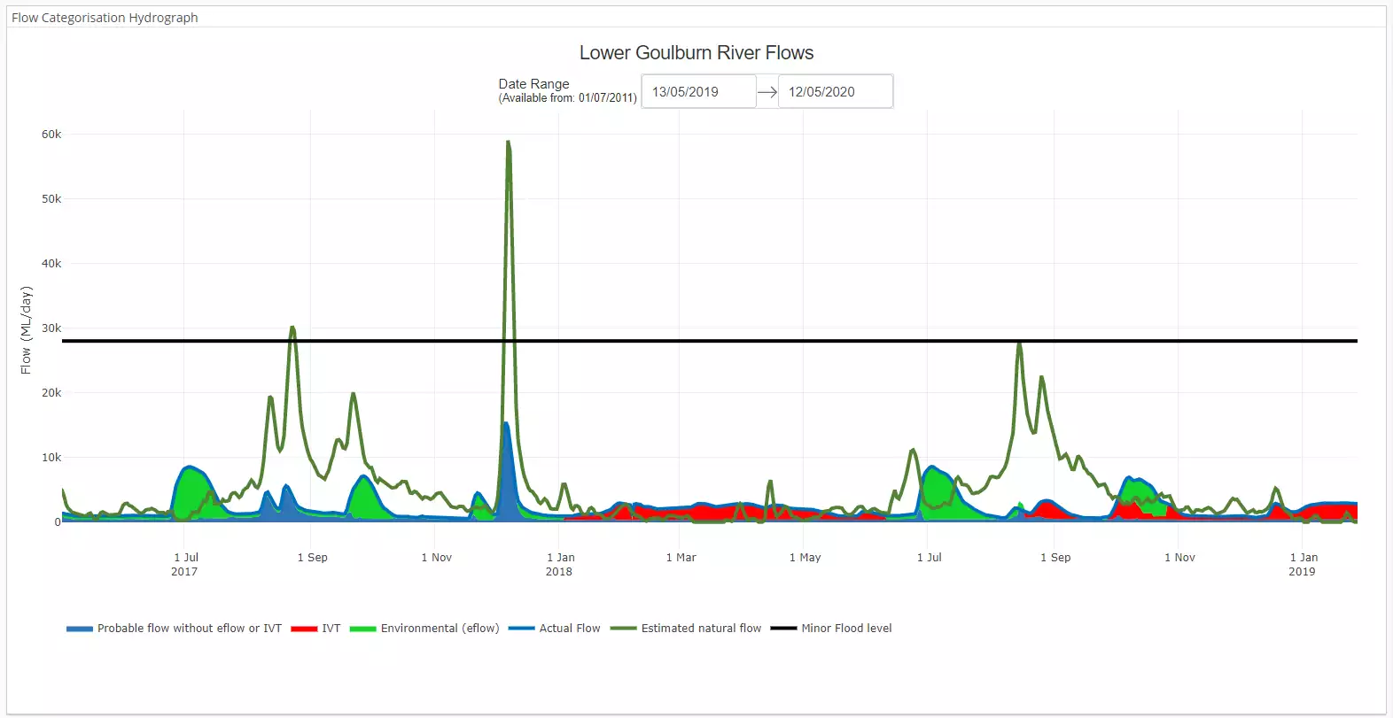
Image: A static image of the Lower Goulburn River hydrograph showing the differences between the estimated natural flow (dark green), actual flow, and sources of water.
Benefits set to flow for Goulburn River this winter

A delivery of water for the environment into the Goulburn River from June will sustain the health of the waterway and benefit platypus, native fish and waterbugs.
Known as a winter fresh, water released from Lake Eildon will increase the height of the mid Goulburn River for a short period as it flows through Alexandra, Molesworth, Seymour, Murchison, Shepparton and further downstream.
Goulburn Broken Catchment Management Authority environmental water manager, Simon Casanelia, said the water delivery would help maintain the health and functioning of the Goulburn River through increasing habitat by moving sediment out of deep pools and putting it on the banks.
“While it’s occurring, the fresh will increase the habitat available for native fish, platypus and water bugs by inundating connected anabranches and wetlands,” Mr Casanelia said.
“Winter is when platypus forage for food and build their nests. The winter fresh reminds the platypus to build their nests nice and high to keep their eggs and young from drowning if the river rises later in the year.”
Mr Casanelia said water for the environment, which is water allocated and managed to improve the health of rivers, wetlands and floodplains, was designed to mimic natural flows that would have occurred before the river was dammed and regulated.
“By providing this water we can do our bit to help replicate natural flows,” he said.
As the water flows out of the Goulburn River it will benefit the Murray River downstream by improving water quality and helping to flush a blue-green algae problem, coinciding with a delivery of water for the environment from the Lower-Darling.
The fresh began on 21 June with flows exceeding 8000ML/day. It will peak in July at approximately 9,500ML/day (a river height of 5.6m at Shepparton) before slowly dropping back to approximately 1000ML/day (a river height of 2.7m at Shepparton) in late July. Peak flows are well below minor flood levels (9.5m at Shepparton). In the case of forecast rain, environmental flow releases may be reduced or stopped.
Environmental flows are planned by the Goulburn Broken CMA in consultation with the Commonwealth Environmental Water Holder (CEWH) and the Victorian Environmental Water Holder (VEWH). The flows are authorised by the VEWH in line with its Seasonal Watering Plan 2023-24. The plan is available for download from www.vewh.vic.gov.au, with regular watering updates posted on the Goulburn Broken CMA website www.gbcma.vic.gov.au.

Climate influence on the lower Goulburn River
Issued: 13 June 2024
The Bureau of Meteorology’s Climate and water long-range forecast for July-September indicates that below average rainfall is likely for the far south-east and south-west of the country, with above average rainfall likely in some southern-central areas and parts of the south coast of Australia. It also indicates warmer than average days and nights are likely across the country.
May rainfall was average to below average across most of Victoria, with drier than average conditions seen on the western side of the Great Dividing Range. Soil moisture is showing drier than average conditions across most of Victoria, with large areas of very dry soils in western Victoria and the western catchments along the Great Dividing Range. These conditions may persist with lower rainfall likely in these areas.
El Nino Southern Oscillation Index – or the ENSO Index – remains neutral. There remains a La Nina watch in place, however this does not mean a La Nina event will occur.
Winter statistics:
| Jul | Aug | Sep | Annual | Years | |
| 13.4 | 14.9 | 18.3 | 22.4 | 1996-2024 (28) | |
| 3.4 | 3.8 | 5.5 | 8.8 | 1996-2024 (28) | |
| 40.6 | 45.0 | 37.2 | 451.0 (Annual total) | 1996-2024 (28) | |
| 8.1 | 7.6 | 6.1 | 61.6 (Annual total) | 1996-2024 (28) |
red = highest value
blue = lowest value
Averages are for Shepparton (site number 081125) and sourced from: Climate statistics for Australian locations (bom.gov.au).
What are our monitoring teams up to in Winter?

Our fish ecologists are currently analysing the results from the 2023-24 water year, while also helping to inform planning for water use in 2024-25.

Our vegetation ecologists are also in the process of analysing and reporting on monitoring from the year just gone. Their work continues to help us understand how the vegetation has responded to several wetter years and how future flows in the river can continue to support growth and condition.
Our monitoring program has a strong focus on channel geomorphology – that is, the structure of the channel. Our geomorphologists continue to map the river bed, banks and bars, to see how the river has changed following recent floods.
The map below shows where we will be doing our monitoring.

Sky high river check

A drone was used to check on the condition of the banks of the lower Goulburn River at Loch Garry recently.
River scientists were analysing high resolution bank images taken with the drone to measure erosion and sediment deposition caused by river flows.
Erosion and deposition of sediment on the banks are natural processes of a river but when there is too much of either, there can be negative impacts.
Scientific monitoring has shown releases of water for the environment in the Goulburn River have promoted the establishment of bank stabilising vegetation and has not caused excessive rates of erosion.
Big hopes for little fish
After being wiped out across the mid-Murray during the Millennium Drought, almost 1200 Southern Pygmy Perch were reintroduced into Red Tank lagoon at Barmah National Park recently.
These small wetland fish have been locally extinct in Barmah since 2007, so this release marks the start of recovery for this species here.
The vegetation and fallen timber in this billabong will provide habitat and protection for these little fellas, who measure about 65mm.
The supply of water for the environment means Red Tank lagoon permanently holds water which will help the fish endure and hopefully thrive. They’ll be checked on early next year, after the breeding season.
These fish were transferred from Bendigo and the release was a collaboration between Goulburn Broken CMA, North Central CMA, Yorta Yorta Nation Aboriginal Corporation, Parks Victoria and NSW National Parks and Wildlife Service. See a short video here.

What’s happening in the Goulburn Broken Catchment?

Dharnya Day is BACK! 💛
Come and say hi to the Goulburn Broken CMA at Yorta Yorta Nation Aboriginal Corporation’s Dharnya Day on Wednesday 10 July, as part of local NAIDOC Week events.
For more information, click here

Feeling snappy? 📸
Head out into nature and take a photo of the amazing native plants, animals and natural landscapes for the 2025 Goulburn Broken Catchment Calendar.
Photographs of local plants or animals in their natural state, insects, waterways or other natural features that tell a story about the Goulburn Broken catchment will be considered. Entries close 13 August 2024.
News from the broader Flow-MER Program

Flow-MER Fridays
In case you missed the Autumn series of Flow-MER Fridays, all sessions are now available to watch at your leisure:
The series line-up includes:
- Environmental Water: Supporting the right plants in the right places
- Flows, fish and connectivity
- Species conservation in the age of uncertainty

Rakali research in the Murrumbidgee
Rakali are a fascinating animal inhabiting many of our wetlands and waterways in eastern Australia.
In the Murrumbidgee Selected Area, Emmalie Sanders, a PhD student with the School of Agricultural, Environmental and Veterinary Science at Charles Sturt University, has spent the last few years undertaking research to understand the role of rakali in the ecosystem and how their presence is impacted by the health of river systems.
In this interview, Emmalie shares her stories of what it’s like to track the charismatic rakali, discusses some of the threats they face, and shares the role that water for the environment can play in their survival.
Thanks for reading this Winter edition of the Goulburn Broken ‘Reading the River’ Seasonal Calendar.
Please subscribe here to receive the next edition in your inbox.
The Reading the River publication has been authored by the Lower Goulburn River Selected Area team of the Flow-MER Program. The work of the Lower Goulburn River Selected Area team is to assess how environmental and consumptive flows are affecting the ecosystem of the Lower Goulburn River, to help waterway managers to protect and enhance this vital water source into the future.
To learn more about the Flow-MER Program,
visit Flow-MER – Environmental Water Monitoring, Evaluation and Research


The Goulburn River is known by several names as it travels first through Taungurung country in the hilly upper and middle reaches. Here, the river is called Waring.
As the river meanders downstream of Murchison and into the northern flatlands, the river winds through Yorta Yorta country. Here the river is called Kaiela, meaning ‘father of waters’. Eventually, the river flows to a confluence with the River Murray near Echuca. This confluence of rivers is known as Koninner.
We acknowledge the Traditional Owners of the country this story has been written about – Taungurung and Yorta Yorta. We pay our respects to elders past, present and emerging.
Artwork credit: Wiradjuri Artist. Rebecca Salcole.