
Following widespread flooding in spring and summer 2022/2023, hypoxic blackwater conditions have developed throughout the Murray River system resulting in fish kills in some areas.
“Unfortunately, the risk of hypoxic blackwater is likely to continue for some time as water temperatures increase in summer,” says Professor Robyn Watts, from Charles Sturt University.
'Blackwater’ is a term used when high levels of organic material and tannins discolour the water making it appear black. The blackwater can become hypoxic (low concentration of oxygen) when the material is broken down by microorganisms, reducing the concentration of oxygen in the water. Concentrations less than 2 mg/L can cause fish and other animals to die.
“For a period of time during the floods river reaches from Barmah downstream to the lower Murray experienced really low dissolved oxygen levels,” says Robyn who leads the Edward Kolety-Wakool Flow-MER (Monitoring, Evaluation and Research) program funded by the Commonwealth Environmental Water Holder (CEWH).
In an effort to save some of the fish in the Edward/Kolety–Wakool River system, CEWH, in collaboration with the NSW DPE Environment and Heritage Group, Murray Irrigation Limited (MIL), and the Edward/Kolety–Wakool Environmental Water Reference Group, delivered small amounts of environmental water through MIL irrigation escapes to the Wakool, Edward/Kolety and Niemur rivers and Thule, Murrain-Yarrein and Cockrans-Jimaringal creeks to provide small areas (or patches) for native fish and other aquatic species so they could take refuge from the declining water quality.

“The environmental water is used to create small ‘refuge patches’ that have higher concentrations of dissolved oxygen that fish and other aquatic animals need to survive. Environmental water delivered from the escapes commenced in October 2022, before the flood peaks came through,” says Robyn. “CEWH wanted to start early to create the refuges and attract fish into them before the oxygen levels in the water in the rivers crashed. Managers have learned from previous experience in the 2016 floods, that you need to start delivering water early to create successful refuges.
“The irrigation canal network had higher levels of dissolved oxygen than river sites because the water in the canal is diverted out of the Murray River at Yarrawonga, upstream of the floodplains and forests where the major carbon inputs occur.”
Because the blackwater was so widespread, environmental water could not be used to dilute the blackwater across the whole river system.
“There is simply not enough good quality water to improve water quality everywhere in the system,” says Robyn. “So instead, the environmental water was used to create small ‘refuges’ of better quality water. Fish and other animals that can access the refuges would have the opportunity to be in better condition, survive and help recover the populations after the flood event.”

As a way of being able to provide rapid feedback to water managers and emergency response committees, and to increase knowledge about the effectiveness of creating refuges using environmental water, scientists from Charles Sturt University and La Trobe University, in collaboration with local citizen scientists, are monitoring water quality and fish responses to refuge flows from the Edward River Escape and Niemur Escape.
“There are a lot of benefits having local people involved in the project,” says Robyn. “Local people can share their knowledge about the river system, and it is also cost-effective to employ local people to be involved in the project because they live locally. It is also an opportunity for local people to help protect the river ecosystem during this hypoxic blackwater event.”
One of the locals involved in this project is Anthony (Ant) Jones, from Deniliquin, who is assisting with water quality measurements; a job he enjoys.

“There’s a lot worse jobs than being in a boat on the river all day,” says Ant. “I think it is good that locals can be involved in this kind of thing. It gives you a better idea and understanding of what is actually happening in the rivers whether it is to do with crays, the fish or the plant life. But we can also share that knowledge with other community members and groups.
“It is good to know that you are out there, whether you are doing a lot or a little, it’s at least helping towards making a bit of a difference and seeing that the environmental water is helping some fish survive.”

The project team is analysing different types of data to help answer four key questions about the outcomes of delivery of environmental water from the escapes:
1. How far downstream of the escape is the refuge created under different flows?
Charles Sturt Univeristy scientists and local citizen scientists in collaboration with the Edward-Wakool Angling Association are taking spot measurements of water quality along the river near the Edward Escape. “This data will help us describe how far downstream the refuge extends under different flows, so we know how large these refuges are,” says Robyn.
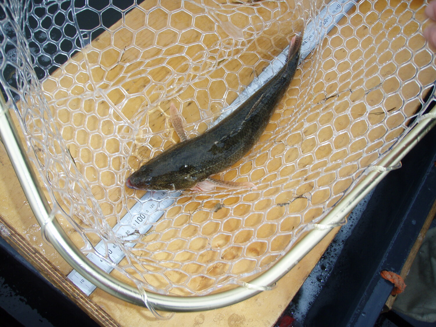
2. Are fish using the refuges created by the delivery of water from the irrigation escapes?
Boat mounted sonar scans are being undertaken by scientists from La Trobe University and CSU to detect the presence and location of fish in the Edward/Kolety River in the vicinity of escapes. Sam Lewis, Research Officer from La Trobe University, says “the good news is that preliminary surveys have indicated a positive response by native fish associated with environmental releases from the escape.”
3. What is the effect of environmental water delivery from irrigation escapes on the water quality in the river system?
Additional water samples are being collected from the river upstream and downstream of escapes and analysed by scientist Dr Sha sha Liu (CSU) to document the levels of carbon and nutrients in the water.

4. How effective is satellite data for measuring water quality responses to environmental watering compared to field observations?
High resolution satellite imagery is being used to examine water quality in the Edward/Kolety river upstream and downstream of the escape. “Using satellite imagery to evaluate changes in turbidity is not a new thing,” says Robyn. “Many people may have previously seen images of flood water going out into the ocean. But this project is an unusual application of remote sensing because the method is being applied to a narrow river channel. The turbid, oxygen rich environmental water from the irrigation channel is being released into very dark, non-turbid blackwater. We are using the satellite imagery to document how far downstream that turbid water goes. The results will be compared with the field measured water quality data to enable us to examine how well the satellite measures changes in water quality. This work will be undertaken by CSU’s Spatial Analysis Network (SPAN).”

“All of these things – the imagery, the water quality data and the fish sonar data – all fit together and will give us a really good information not only for rapid feedback for managers right now but to learn for and to monitor subsequent events,” says Robyn.
The escape flows and monitoring will continue until February 2023.
Latest info on Commonwealth environmental water delivery from MIL escapes can be found here: https://www.dcceew.gov.au/water/CEWH/catchment/mid-murray/water-use

%20(1).webp)
.jpg)