Spring Update | 2023
“Life is good, but it’s better on rivers.”
Explore the Lower Goulburn River as it changes through the seasons.
Reading the Goulburn River
Reading the Goulburn River
Stop Press! High rainfall in early October sees rivers rising again
The Spring Update of Reading the River was published in September which saw dry conditions across the state. In early October, a significant rainfall event has swept through eastern Australia seeing widespread falls of 100mm or more. With rivers rising fast – including rivers in the Goulburn and Broken Catchments – water managers are currently watching river responses to see what it means for their current plans for the Spring-Summer ahead, including the second Spring Fresh outlined below. This latest rainfall event is another reminder of how dynamic our environment is in Australia. Stay tuned for the Summer edition of Reading the River, where we’ll discuss the October rainfall event in more detail and what it means for the year ahead.
COVER STORY
Goulburn River and floodplain connected for second year in a row!
For the second year running, the Goulburn River has reconnected to the floodplain. The high unregulated flows (mentioned in the winter edition of this newsletter) continued for most of Winter.

Multiple rainfall events saw high inflows from the tributaries and required pre-releases to be made from Lake Eildon. Pre-releases are water releases made from dams to reduce future flooding impacts.
These conditions saw the flows at McCoys Bridge remaining above 10,000 megalitres per day from 11 June until 4 August peaking at 22,500 megalitres per day at the start of July – baseflows are usually 800-1000 megalitres per day.
Although 22,500 megalitres per day is still below minor flood level, and far lower than the estimated 190,000 megalitres per day in 2022, significant parts of the floodplain were inundated, providing habitat to fish, birds and macroinvertebrates alike. After six years with no over bank flows, this second floodplain reconnection in 12 months will provide floodplain vegetation some resilience to the potential dry conditions that are forecast in the coming months.

Water for the environment building on natural flows
Spring is the time for reproduction and growth. It is a critical time for native fish, and other animals, vegetation and bugs.
For this reason, Spring is when environmental water managers create ‘freshes’, or pulses of water to trigger native species accustomed to Winter-Spring rainfall to drive their life-cycles.
With the catchment now starting to dry off and flows returning to more ‘normal’ operating levels, water managers are looking to provide this seasonal variability in the system. In early September, a Spring Fresh commenced and will continue to reach a flow to peak between 7,300 megalitres per day and 10,500 megaliters per day, for approximately one week, before decreasing slowly to low flows. This Spring Fresh will connect low lying wetlands in the mid-Goulburn that were recently inundated in Winter and will provide an opportunity for aquatic biota such as water bugs, yabbies and small fish to access the wetlands.
The higher flows in the lower Goulburn River will increase moisture in the bank to encourage growth of existing vegetation and also promote the germination of any seeds deposited on the banks during winter flows. The hydrograph (above) shows the release required from Lake Eildon to enable the Spring Fresh to work its way down the lower Goulburn River, taking approximately two or so days to reach Murchison. The slightly higher flow at Murchison is a result of tributary in-flows in between.

What is a hydrograph?
A hydrograph is a graph which shows flows in a river over time, at a particular location. They are a useful tool used by agencies around to world to both plan for how flows may look (such as the one above) and can also be used to show how actual flows occurred after an event.
The Goulburn-Broken CMA has developed a live hydrograph so that you can see whether flows in the river are operational flows, including Inter-Valley Transfers, or water for the environment. See what the hydrograph looks like below and for the live version, please visit the live website to explore.
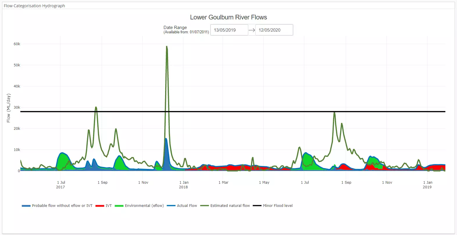
Caption: A static image of the Lower Goulburn River hydrograph showing the differences between the estimated natural flow (dark green), actual flow, and sources of water.
 speaking to students on the Goulburn River")
Outdoor Education on the Lower Goulburn River
On Tuesday 29th August, 2023, students from the Greater Shepparton Secondary College joined scientists from the Lower Goulburn Flow-MER project on the banks of the Goulburn River to get their hands dirty and learn more about environmental flows. Students across Years 10 and 11 currently studying outdoor education and environmental science had the opportunity to participate in two workshops over the course of the day and test their knowledge of environmental flows, macroinvertebrates and geomorphology, while also being given the chance to learn some of the techniques used to monitor the river.
What can we expect through Spring on the Lower Goulburn River?
After the first Spring Fresh delivered in early September, environmental water managers will support baseflows over Spring. Baseflows are important for a range of reasons, including enabling species such as Murray cod to nest and raise their young. In later Spring, water managers will look to do a second fresh between October to December. This fresh is targeted towards fish which need higher flows to spawn, namely golden and silver perch. The second Spring Fresh will provide a mix of flowing habitat to enable fish eggs and larvae to drift, scour sediment from riffles and promote water bugs to breed for the health of the system and provide much needed fish food.
 Plans for what environmental water managers have in store each water year are outlined in the Victorian Environmental Water Holder’s Seasonal Watering Plan. Find out what is planned for the Goulburn River and other Northern Victorian Rivers at Seasonal Watering Plan 2023-24: Section 05 (vewh.vic.gov.au).
Spring outlook:
| September | October | November | |
| 18.2 | 22.2 | 26.2 | |
| 5.5 | 7.5 | 10.8 | |
| 38 | 35.4 | 45.8 | |
| 6.3 | 5.2 | 4.8 |
Averages are for Shepparton and sourced from: Climate statistics for Australian locations (bom.gov.au).
The Bureau of Meteorology has posted their Spring outlook which is indicating warmer and drier conditions for south-eastern Australia. For our region, this could mean less inflows and increasing demands from water users both locally and downstream along the Murray River. Wetter catchments may see higher streamflow responses in south-eastern Australia though, so we will be keeping an eye on how catchments respond to rainfall. We encourage you to see the Bureau’s Spring outlook below:
Long-range forecast overview
Issued: 14 September 2023
- October to December rainfall is likely to be below median for much of Australia away from inland northern areas.
- October to December maximum temperatures are very likely to be above median across Australia, and likely greater than 80% chance for almost all of Australia.
- October to December minimum temperatures are very likely to be above median almost nationwide.
- The long-range forecast is influenced by several factors, including likely El Niño and positive Indian Ocean Dipole development, and record warm oceans globally.
What are our monitoring teams up to?
With Spring being such a critical time for the river, you’ll see all our monitoring teams out and about over the coming months.

Our fish ecologists will be out using a range of techniques to detect fish spawning, to see how species such as Murray cod, trout cod, golden perch and silver perch are responding to flows.

Our vegetation ecologists will be out along the banks measuring the cover and range of species which have grown this year, with a keen eye to see how two high flow years have changed things.

Our monitoring program has a strong focus on channel geomorphology – that is, the structure of the channel. Already this Spring, our geomorphologists have been out with their drones to map the river bed, banks and bars, to see how the river has changed.

Our macroinvertebrate crew will be measuring water bugs, shrimps and yabbies to see how they’re responding to Spring flows this year.

Water quality is a critical part of understanding what is happening in the system. We’ve learned so much from the ‘stream metabolism’ monitoring we’ve undertaken over the past eight years, and water quality loggers are again out in place to measure the dissolved oxygen levels in the river.
The map below shows where we will be doing our monitoring.

With fish and vegetation a key focus this spring, hear from Dr Wayne Koster and Dr Kay Morris from the Arthur Rylah Institute, leading our fish and vegetation monitoring.
Results from 2021–22
Monitoring in 2021–22 identified some important aspects for both vegetation and fish. For vegetation, spring freshes seem to provide both the seed deposition and moisture conditions required to support growth higher on the banks. Vegetation on the lower banks remains susceptible to impacts from prolonged wetting from summer deliveries of Inter Valley Transfers. Fish sampling saw large numbers of Murray cod and this is a promising sign of recovery following the 2017 hypoxic blackwater events. For further results from 2021–22 monitoring, see the summary report here.
Fish Ecologist Dr Wayne Koster shares what eight years of monitoring in the Goulburn River has taught us about the native fish in the system, and how we can manage flows to increase their numbers.
Fringing vegetation is critical to the health and stability of the riverbanks in the Goulburn River. Dr Kay Morris shares what long-term monitoring has shown for bank vegetation and the importance of managing all water to sustain healthy riparian zones.
What can you look out for this Spring, and where?

Cool critters! The incredible shield shrimp
Shield shrimp, otherwise known as Notostraca, are a type of crustacean that have adapted to Australia’s tough environment. Shield shrimp are so tough that they’ve even been found in temporary pools on Uluru! How is this possible? The eggs are still viable even when dried and blown around the landscape. After rain, microscopic larvae hatch and eventually become adult shield shrimp that feed on bacteria, algae and plant material. The shield shrimp pictured here was found in a flood runner adjacent to the Goulburn River north of Shepparton which received water during the recent high flows.
Exploring your river on foot: The Australian Botanic Gardens Shepparton
Located adjacent to the Broken River just before it meets the Goulburn River, there are multiple walks within the Botanic Gardens that can be enjoyed by people of all abilities. Take the challenge of walking up the ‘big hill’ to get a bird’s eye view of the Goulburn-Broken catchment, with signage at the top to highlight key features. For the energetic, there is the option to walk or ride from the Gardens along the Goulburn River to Shepparton’s Victoria Park Lake. Historically the site was landfill and many hours have been spent regenerating the area to be a place that highlights Australian native plants and the natural bushland adjacent to the Goulburn and Broken rivers.
For further information:
Australian Botanic Gardens Shepparton – Greater Shepparton City Council (www.greatershepparton.com.au)
Friends of the Australian Botanic Gardens Shepparton (www.fabgs.org.au)

Australian Botanical Gardens Shepparton has multiple walking tracks to choose from.

Take the family for a walk or picnic at the gardens.
World Rivers Day 2023

Let’s come together to celebrate our rivers on World Rivers Day – a morning of free school holiday fun for the whole family including the first ever River Run Race!
Picture this, you gather a team, create a theme and costume, and build a craft to race on land. Has your team got what it takes? Everyone is welcome with many other stalls, activities, food and entertainment to be had as we bring a whole new way to celebrate our rivers to the region.
When: Sun, 24 Sep 2023 at 9:00am – to 12:00pm
Where: Victoria Park Lake (Northern grassed area opposite KFC)
Cost: FREE
Contact: Alison White on 58329714 or riverconnect@shepparton.vic.gov.au
Website: www.riverconnect.com.au/river-run
News from the broader Flow-MER Program

Needle in a haystack!
A chance discovery of one of the Murray-Darling Basin’s endangered fish has been made in the lower Lachlan river system, NSW. Hear from fish ecologist Dr Adam Kerezsy of how he stumbled upon a healthy population of Olive perchlet – also called ‘glassfish’ – in a network of lakes and earthen tanks in outback NSW.

New Food Webs and Water Quality page
Over the past seven years, we have been monitoring and evaluating how water for the environment is being used to support food webs and water quality across the Murray-Darling Basin. Data from the Lower Goulburn River has contributed to this analysis, and the results are fascinating.
Thanks for reading this Spring edition of the Goulburn Broken ‘Reading the River’ Seasonal Calendar.
Please subscribe here to receive the Summer edition in your inbox.
The Reading the River publication has been authored by the Lower Goulburn River Selected Area team of the Flow-MER Program. The work of the Lower Goulburn River Selected Area team is to assess how environmental and consumptive flows are affecting the ecosystem of the Lower Goulburn River, to help waterway managers to protect and enhance this vital water source into the future.
To learn more about the Flow-MER Program,
visit Flow-MER – Environmental Water Monitoring, Evaluation and Research
![]()

The Goulburn River is known by several names as it travels first through Taungurung country in the hilly upper and middle reaches. Here, the river is called Waring.
As the river meanders downstream of Murchison and into the northern flatlands, the river winds through Yorta Yorta country. Here the river is called Kaiela, meaning ‘father of waters’. Eventually, the river flows to a confluence with the River Murray near Echuca. This confluence of rivers is known as Koninner.
We acknowledge the Traditional Owners of the country this story has been written about – Taungurung and Yorta Yorta. We pay our respects to elders past, present and emerging.
Artwork credit: Wiradjuri Artist. Rebecca Salcole.